I live up in the Boulder area, along the Front Range of Colorado, and every winter mass numbers of human apes make the annual pilgrimage from "The Centennial State" down to the "Lone Star State" to test their strength (and finger tips) at Hueco Tanks State Park. Perhaps one of the finest bouldering areas in the world, and one of the top 5 in the US, Hueco is the place to go - and be seen - during the winter months.
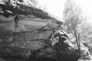
Most people from the Front Range just bomb it straight down, missing the excellent bouldering to be found along the way, such as the stuff in Deer Creek Canyon or up on Glorieta Mesa - both out of Santa Fe. Another spot that will get you ready for Hueco's steep overhangs can be found just outside of Las Vegas. Sitting on the eastern side of the Sangre de Cristo mountains, Las Vegas resides on the outer edge of a massive granite playground. But before one reaches the granite, as is often the case along the Front Range of the Rocky Mountains, one crosses over another layer of stone. In this case, it is some limestone-type riverbed sandstone overhanging mud stone.
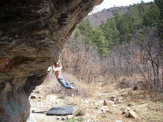
Facing southeast, this little bouldering cave gets sun all winter long, making it the perfect stop along the way for stretching the limbs, pulling on some roof problems, doing some long link-ups, or establishing some new problems on the boulders found in the vicinity. Once you have had a nice long session, drop by the hot springs and soak those bones before you get back in the car and make the rest of the drive to Hueco.
It's like a much wider version of the CATs cave, with problems going left, right, straight out, and everything in between. So next fall or winter, when the Colorado Front Range is wet or under snow, head on down. This place will be dry and warm, and not a soul will be around.
Sunday, April 26, 2009
Friday, April 17, 2009
Colorado and New Mexico Adventure Trail Running: Recent Trips
I'm a real big fan of what I call "Adventure Trail Running." This is where you find a trail - usually on a map at poor resolution - and decide to run it. Other times, it can simply be finding a peak or mountain that you want to run, finding the closest access point, and heading up on old trails or animal paths. I've been doing this for years all over Colorado and New Mexico, and I figured I would share a couple. Why? Well, I doubt anyone will actually go and do these trail runs. They are not easy to find. They don't have clear, wide pathways where you can get up a good gait. There are river crossings, serious bushwhacking, talus slopes, exposure, canyons to surmount, and the like. But that is the whole adventure; running a trail or obscure path that perhaps has not seen another human for years and years.
Reminded by my run yesterday from Eldora (~9,000 feet) to the 4th of July Mine (~12,000 feet) on several feet of snow (it was possible to make it all the way as of April 16), I thought I would mention two recent adventure runs.
Canones Creek Trail in the Jemez Mountains of New Mexico
This is one of those classic adventure runs. After driving around on some old dirt forest roads out of Coyote, New Mexico, one finds a beautiful old trail that runs along Canones Creek in the heart of the Jemez Mountains. Although the trail is rarely used now, and involves several exciting river crossings, it offers the trail runner an adventure that takes them back in time.
Originally used by the local Native Americans as a trail for going between the pueblos along the Rio Grande into the high Jemez Mountain calderas for hunting and gathering in the summer, the trail was then "improved" after WWII. Since that time, it has seen little traffic and has slowly begun to revert back to its original state. However, one can still run it for over 8 miles one way, as they cruz along the beautiful Canones Creek.
To find it, drive on Highway 96 towards Coyote, and make a left turn onto Forest Road 100 (heading south). Follow this for around 8 miles until there is a turnoff on your left. This turnoff splits: one going back north and around to a spectacular overlook and the other heading south and down to the creek. Park and run here (unless you have serious 4 x 4 traction). Technically, this is called FR 173 but there are no signs. Run down to the creek, and then you have the option of doing a small 8 mile loop back up and around or crossing the creek and heading down the Canones Creek Trail.
There are lots of wildlife in the area, including wild turkeys, hawks, eagles, and mountain lions. Bring some water, a camera, and head out for a trail running adventure. When you are done, drive the 30 miles to Cuba, New Mexico and grab some excellent New Mexican food. Then head back over towards Jemez and hit up one of the hot springs.
Apache Canyon in Southern Colorado
Here is another classic adventure trail run located in a spectacular canyon with 500 foot walls on both sides. The trail, which was originally built by people working on one of the "New Deal" projects set up by President Franklin D. Roosevelt, is now an overgrown jungle of sheer canyon walls, creek crossings, waterfalls, and deep foilage. However, that should not stop anyone, as you can take this trail for over 8 miles until it eventually connects with the Bartlett Trail, eventually reaching the top of Greenhorn Mountain (12,347 feet).
Heading north out of Walsenburg on I-25, take a left onto road 650. Follow this road as it slowly climbs into the gamble oaks at the base of the Wet Mountains. On the map it looks like this road eventually connects with road 271, but that is incorrect. Follow the road all the way until it deadends at a house (with a big dog), and then look due west. There is a small deer trail that leads you to the old trailhead. Taking this trail, one can enter an entirely different ecosystem then the one where they parked, losing track of all time and place. Enjoy, because you are probably the first person on the trail since I ran it.
Both of these trails are perfect examples of adventure trail running. Rediscover some of the lost places in the Rocky Mountains - there are more then you think.
Friday, April 10, 2009
Deer Creek/Apache Canyon Bouldering in New Mexico
I'm a little back-logged on old posts, but I guess that is the way things go when you spend more time outside in the mountains then in front of a computer. However, there are still a couple of posts I need to get up on the last trip to northern New Mexico for some trail running and bouldering.
While I was ostensibly in Santa Fe for a conference (the SfAAs), we still managed to find time to get out for several good bouldering sessions and a couple long trail runs. One of the best bouldering spots found close to Santa Fe is Deer Canyon. Mistakenly called Apache Canyon, this little bouldering playground reminds me of a way cooler version of Morrison. The main overhanging section has as many problems and eliminates as you can imagine. There are some power problems going straight up, or you can traverse into some sloppy fun from either the left or right.
Behind this main section rests two more massive boulders that deserve mention. The first one has a real gem on its northwest side. An angling arete problem, this one is a show stopper unless you are strong, able to squeeze open hand holds, and can keep your feet pasted. It goes at around V10.
The boulder right next door also has some fun problems on it, although one of the nicer lines has two modified handholds which kinda takes away from the area. Up the hill are a couple more boulders with some undone lines, as well as up the creek. However, the main concentration are right in this one area.
This place is great in the fall when the little Deer Creek has dried up and all of the low sit-starts are open. Easy to get a full session in and tick a couple of really nice V5-V10 problems. After a good session, head back to Santa Fe for some solid New Mexican food.
Saturday, April 4, 2009
Colorado Backcountry Days: Telemark Video on Classic Colorado Backcountry
Well, it has been dumping again here in Colorado, so we have been up filming and getting in a few more powder days before the telemark season comes to a close (at the resorts that is; we should have a couple months still of some good spring corn skiing). In honor of all the skinning we have been doing, we put together this little video called Colorado Backcountry Days.
If you enjoyed the video, please leave a comment. Or, you can watch others from the list below.
I think it is fairly typical in giving a flavor of the Colorado backcountry. It has it all: wind, skinning, sunny days, wind, high peaks, empty bowls, wind, and more. Utah may be known for its mid-winter backcountry, but Colorado has some of the best spring telemark skiing in the States. This is just to keep us psyched a little longer - don't put the skins away yet...
Subscribe to:
Posts (Atom)