Showing posts with label Project N. Show all posts

Monday, February 10, 2014

Saturday Marathon

Saturday Marathon


With another long run on tap, William and I decided to try and link together a bunch of parks and open space in Jefferson County instead of doing one of the usual loops up in Boulder. Boulder is great - I grew up there and have run those trails forever - but the idea of an adventure run closer to home was appealing. Allisa had mentioned a crazy 100K route that linked up a ton of parks - we were not up for that, but still wanted to do something similar, so we devised a plan and headed out. We parked at the top of the Mathews/Winter trailhead and headed up the Red Rocks trail. At the top of the mesa, we went bushwacking straight up the northeast ridge of Mt. Morrison. This turned out to be a bit of a saga, as the snow was ankle to calf deep the entire way - not more slogging! Near the top, you have to go around a bunch of radio towers with various warnings about radio frequency exposure and FCC guidelines. Finally, at the top of Mt. Morrison we ran down the super fun and fast southeast ridge to Morrison and Bear Creek. A quick run through some urban streets and we were hooked up with the Mt. Falcon trail system. Up that we went - the trail was packed out, but the wind up top was roaring and had us back to a slogging pace. At the top of Falcon, we dropped off the backside and down through the Indian Hills area. Our original plan was to then jump onto the O'Fallon/Lair O'Bear trails which would take us to the small hamlet of Idledale. When we got to the trails, they were totally untracked and our desire to turn this run into a mega epic (it was already turning into a mini epic) quickly convinced us to just cruz down Myers Gulch to the hamlet of Kittredge and then onto the lower Bear Creek trails. Once in Idledale, we had to run a couple miles along the side of the road to get back to Morrison, where we turned and went up through Red Rocks and back along the trails to get to our starting point. The run turned out to be almost exactly 26.2 miles (26 via Google Earth) and 6,477 feet of gain. I was blasted by the end, with William dropping me four or five times. It was a great training run, incorporating some good climbing and a fair amount of real running. As seems to be the usual habit, I took some photos during the first half, but nothing during the second half.

 Slogging up Mt. Morrison
Views from the top of Mt. Morrison
Windy madness along the Divide
The meadow at the top of Falcon

Sunday, January 26, 2014

Full Skyline

Full Skyline


Cruzed the Skyline traverse with William again. Such a good line, with several climbs and descents. I always find it hard to re-start my heart rate coming off of one of the descents and into the next climb. This traverse works that weakness really well. We made good time up to SoBo and then over to Bear, as the peaks were quiet and empty. Put in a solid effort up to Green, where we ran into Scott Jurek. Really great guy - chatted, exchanged trail beta, etc. After the uninspiring summit of Flag, we ran into Kendrick on the backside. Obviously our motivation was waning as we again stopped and talked. By the time we got over to Sanitas, it was hot and every person in Boulder and their dog were out. We tried to cruz up, but there were so many people we just sorta had to go with the flow. I can see Kendrick's argument for doing the traverse the other direction, as you end away from the crowds. However, putting in Sanitas and its stair-step climbing at the end adds a little kick. Stopped taking photos after Bear for some reason...
 William cruzing through the burn zone...
 Bear from SoBo...
 The Divide...


Saturday, January 18, 2014

SoBo, Bear, Green, Bear, SoBo

SoBo, Bear, Green, Bear, SoBo

Great day on the trails with William. After yesterday, I wasn't too sure how I would feel, but I was able to keep on trucking which was a pleasant surprise. Shadow was a bit dicey, but not too bad, while the rest of the route is good to go. No traction necessary. This is such a great route - you get a solid vertical k in the first climb, with the rest of the route being very runable. Fair number of runners out this morning - the training season has begun!


Saturday, January 4, 2014

Snow Slog - SoBo, Bear, Green

Snow Slog - SoBo, Bear, Green

I had planned on running the SoBo > Bear > Green > Bear > SoBo with William today, as he had never done the Skyline run. However, with the snow, we had to change up our plans a bit. We started out from the S. Table trailhead right before 8:00am and there was already 4 inches or more on the trails. We cruzed up Homestead, which had two sets of tracks before we turned and went up Shadow Canyon. No one had been up Shadow yet, and so that turned into a fun session of power hiking in 4-6 inches as we tried to not slide all over the rocks and still stay on the trail. Near the saddle, I saw some bits of blue sky and thought that the storm was breaking up, but I was dead wrong. After sliding our way to the top of SoBo, we cruzed down and made our way over to Bear. Again, no tracks on Bear. The storm at this point decided to pick up steam, and as we went down the West Ridge, the snow really started dumping. We were still in positive spirits, but we were both questioning whether we wanted to go down Shadow. We broke trail up Bear Green all the way, and not until hitting the Ranger trail did we see another set of tracks since the Mesa trail early on. There were two sets - one I figured was Jeff's, and the other was from someone we ran into near the top of Green who was on his way down. The storm was really dumping now, and so we decided to go back down Bear Green and then down Bear Canyon to the Mesa trail. Coming back down, there were sections that had at least a foot of snow or more, as we broke trail down Bear Canyon until near the bottom when we ran into one runner and a couple hikers. I was psyched to finally run into people so that we didn't have to continue to break trail. We turned, and then followed the Mesa trail along until reaching the new Upper Big Bluestem trail, which we opted to go down to check it out. It was fun, fast, and smooth. I think the new re-route is very well done. Finally, after a couple hours of slogging through too much snow, we made it back to the car. Not the best day perhaps for an intro to the Skyline, but I was sure to point out that the next time he does it, it will be easier!
 Moving up Shadow with the least amount of snow of the day...
 Looking west from the top of SoBo...
 Looking north from SoBo...
 The trail down Bear's West Ridge...
Top of Green...

Friday, November 29, 2013

South Boulder, Bear, Green, Bear, South Boulder - And Altitude Training and Energy Costs During an Ultra

South Boulder, Bear, Green, Bear, South Boulder - And Altitude Training and Energy Costs During an Ultra


I figured that the day after Thanksgiving would be a good day to do the Skyline Traverse, as I would most likely run into some other runners and have some company. Not so. In fact, I didn't see any other runners out there, which was odd. Isn't today Fat Ass Day One? Either way, there were tons of hikers and walkers, but no one to share the trails with, so I went solo. Parked at the newly re-opened South Mesa trailhead and cruzed up the newly re-routed Homestead trail. As with other trails in the Boulder Park system that get re-routed, the new Homestead trail is nice and smooth. A tad longer, but not as steep and with less stair-steps and rocks. I don't really understand this trend to re-route trails to make them smoother and easier (well, I can see OSMP's logic in terms of the general populace, but it does take away from the "adventure" part of being in the woods). After Homestead, which now drops you onto the S. Mesa trail at a different spot then the old trail, I went up Shadow Canyon, which is one of my favorites. It is the closest trail to being in the mountains that I know of on the front range - steep, lots of rocks, stair-steps, etc. The flood exposed a lot of roots and added a ton of smaller cobbles to the trail, making it even more fun then before. No one on top of S. Boulder, but a gaggle of people on Bear. Cruzing down Bear's West Ridge is always fun, and the new Bear-Green trail is super smooth (like the other re-routed trails - buff or butter smooth as some say). Green's summit had a bunch of people, more walkers coming from the West Ridge route then Bear (which has more hikers). Once I tagged Green, I turned around and returned via the same route, tagging Bear and S. Boulder once more.

I'm always amazed at how vertical can make things go so much slower, and make the miles feel so much longer. Yesterday (T-day) I did 13 miles with 6 mile repeats thrown in in 1:25. Today, with all of these peaks, I only did 16 miles in 4:03. Of course, there was 6,838 feet of climbing, but it really still strikes me the difference in perceived physical and mental effort.

A new article in the British Journal of Sports Medicine discusses altitude training, VO2max, and haemoglobin. They conclude that altitude training can increase one's VO2max by half the magnitude of the increase in haemoglobin mass. That is a fairly large increase in VO2max! Of course, as they note, that may or may not translate to better race performances because of other factors. However, it seems pretty hard to argued against altitude training if one is planning on racing as sea level.

The other article, in the Journal of Experimental Biology, looked at factors affecting energy cost of running during an ultra. To cut to the chase, the authors found that greater muscular power and a lower foot-print index result in better performances in ultras. Foot-print index is basically your arch height and amount of your foot that hits the ground. So, in a way, they found that if you are stronger and run with more of a mid- to fore-foot strike pattern, you have a chance of performing better in ultras then if not. Of course, like above, there are TONs of other factors that go into solid performances, but it is something to think about. No heel-to-toe running, even when tired. And practice good form, over and over and over again.

Friday, November 15, 2013

Mt. Falcon X 4

Mt. Falcon X 4

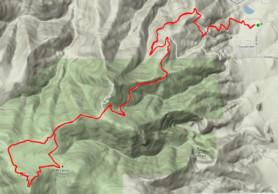
The goal was to get out for an extended period of time, and to try and get in some vertical. I was looking for something where I didn't have to carry all of my food and water, but still had a decent amount of miles and vert per lap. Green Mountain via one of the front side trails was my first choice, but since that is still closed, I opted for laps on Mt. Falcon. The route is straightforward, up to the fire lookout and back down. Each lap is 8.5 miles and 2,100' of gain. I wasn't looking to push the pace, but rather to keep moving up and down for an extended period of time, and to focus on any mental issues that might arise. After allowing myself an extra hour of sleep to try and catch up from a busy week, I got moving at 8:06 in the morning. Regularly, when I run this route semi-hard, it takes me ~1:20, so I was aiming for just under 2 hours per lap on this day. The day started off a bit cool, but quickly warmed up and I was in summer mode for the rest of the day. The first lap went well, and I finished it off in around 1:45 at a very comfortable pace. A quick stop at the car for some food and water, and I was off again after a couple minutes. The second lap went well, and my energy level seemed to be holding. The third and fourth also went well. I was worried that I would get bored and throw in the towel prior to reaching four laps, so I had that goal in the back of my mind all day. I also wanted to try and keep a mellow but even pace all day, which I was able to do. So, overall the day was a success. I still had enough energy after the fourth lap to go for another, but decided to call it at four - a solid training day with my goals accomplished. 34 miles, 8,400' of gain, 6h 53m. Project N training.