Early December Mix - Quick Freeheel Video
Well, we have been hitting the BC and resort. Getting in lots of days on the snow. Messing around with our free video software...
Freeheel Early December Mix from Peter Jones on Vimeo.
Tuesday, December 7, 2010
Friday, November 19, 2010
Early November Backcountry Powder - Freeheel Video in Colorado
Early November Backcountry Powder - Freeheel Video In Colorado
We got dumped on during the first two weeks of November, so I put together this little video of some of the powder. The telemark season is off to a great start, let's hope the snow keeps coming. All the footage is from the BC.
Day La - Telemark Powder Early November 2010 from Peter Jones on Vimeo.
We got dumped on during the first two weeks of November, so I put together this little video of some of the powder. The telemark season is off to a great start, let's hope the snow keeps coming. All the footage is from the BC.
Day La - Telemark Powder Early November 2010 from Peter Jones on Vimeo.
Saturday, November 13, 2010
Powder Days in November: Backcountry Freeheel Skiing
Powder Days In November: Backcountry Freeheel Skiing
Today we reached 22,000 vertical feet for backcountry skiing this year. That's 22,000 feet up and another 22,000 down. Not bad for all the vert being in the BC and on teles. What is even more incredible is that most days have been nice powder days. Like today, 3,000 vert and face shots before noon. Working on a vid, but until then here are a couple photos.


Today we reached 22,000 vertical feet for backcountry skiing this year. That's 22,000 feet up and another 22,000 down. Not bad for all the vert being in the BC and on teles. What is even more incredible is that most days have been nice powder days. Like today, 3,000 vert and face shots before noon. Working on a vid, but until then here are a couple photos.

Skin track stoke!


Tara hitting the powder!

Deep powder in the XYZ Chutes...
Saturday, November 6, 2010
Freeheel Powder Skiing in Early November: Another Telemark Video
Freeheel Powder Skiing In Early November: Another Telemark Video
November 1 - 2010 from Peter Jones on Vimeo.
I put together a short clip of
the amazing powder conditions we had on the first of November. With only
2 storms, the conditions are surprisingly good. Hopefully the storms
that are supposed to roll through all next week one after the other will
dump some more. Despite the good teleing, more snow to cover the rocks
and grass is much needed. Hope you enjoy. Also, check out the earlier video of October freeheel powder skiing in Colorado.
Monday, November 1, 2010
White October: Video of Couple Freeheel Backcountry Days
White October: Video Of Couple Freeheel Backcountry Days In October 2010
White October 2010 from Peter Jones on Vimeo.
We put together a really short clip of some shots from the last week of October. We thought we were going to end the month with no turns, but thanks to a massive storm, there was plenty of snow! Always good to start the telemark season off with some backcountry powder to feed the freeheel addiction. We got some better turns today, so I hope I can put it up soon. Enjoy!
Sunday, October 24, 2010
Mountain Running Byers Peak: A Final Trail Run for the Season
Mountain Running Byers Peak: A Final Trail Run For The Season
A couple days ago we decided to run Byers Peak. This is a local peak, and with some of the snow from the last storm melted, we thought we would give it a go. It is always nice to close out the trail running season with one more peak under your belt. Byers Peak is a perfect one. The trail is well marked, its steep, and the views are spectacular.


The numbers for those who care....
Distance Roundtrip: ~8.6 miles roundtrip
Start Elevation: ~9,900 feet
High Point: ~12,804 feet
Total climbing and descending: ~3,808 feet
Difficulty: Medium
Other People Factor: Minimal Time: 2 - 5 hours depending on how often you stop to enjoy the views.
A couple days ago we decided to run Byers Peak. This is a local peak, and with some of the snow from the last storm melted, we thought we would give it a go. It is always nice to close out the trail running season with one more peak under your belt. Byers Peak is a perfect one. The trail is well marked, its steep, and the views are spectacular.

Looking back down the snow covered ridge...


With the snows up top, there was not a single person on the entire mountain or in the surrounding woods. Mountain running late in the season like this is just perfect. Despite the 1-2 feet of snow on the final mile long ridge, we managed to do this run in 2:37 roundtrip.

The ubiquitous summit shot...
The numbers for those who care....
Distance Roundtrip: ~8.6 miles roundtrip
Start Elevation: ~9,900 feet
High Point: ~12,804 feet
Total climbing and descending: ~3,808 feet
Difficulty: Medium
Other People Factor: Minimal Time: 2 - 5 hours depending on how often you stop to enjoy the views.
Wednesday, October 20, 2010
Trail Running the High Lonesome Trail
Trail Running The High Lonesome Trail: Sweet Running Through Forests And Meadows In The Mountains
The other day Tara and I decided to run the High Lonesome Trail. This is a really good trail that follows part of the Continental Divide Trail and passes through numerous high-mountain meadows and forests. We ran the trail from Devil's Thumb Park to Meadow Creek Reservoir and back. You can keep going all the way to Monarch Lake to the north, or you can cruz up Devil's Thumb Pass on the south. Since we have been doing a lot of longer runs, we wanted something a little mellow. Plus, there is snow up on the pass making any running up there difficult.


The trail is fairly easy, as it meanders along from north to south at the base of the Divide. The numerous mountain meadows or "parks" are beautiful, and worth a quick stop at each one. The trail sees little traffic, so you are likely to be the only runner out that day.
Saturday, October 2, 2010
Trail Running St. Louis Lake: Peaceful Mountain Running in the Proposed Williams Fork Wilderness
Trail Running St. Louis Lake: Peaceful Mountain Running In The Proposed Williams Fork Wilderness


The numbers for those who care....
Beginning Elevation: ~10,240 feet
High Point: ~11,600 feet
Total climbing and descending: ~2,720 feet
Mileage: ~13 miles roundtrip
Other People Factor: minimal
Time: 2-5 hours depending on how often you stop to enjoy the views...
Early this morning Tara and I set out for a nice long mountain trail run. We decided to cruz up to St. Louis Lake up high on the shoulders of St. Louis Peak in the proposed Williams Fork Wilderness. This is a beautiful area that is surrounded by forests and lesser-known mountains, with little or no traffic. Approaches are long and convoluted, so your chances of seeing people are pretty slim - except on the highest of traffic days. St. Louis Peak, Bills Peak, Bryers Peak, and other bumps compose this massive uplift of mountains that has only 2 real access points. The St. Louis Creek road is the one we chose this time.

The actual "trailhead" after 3 miles of running...
Drive 7.5 miles from Fraser along the St. Louis Creek road until it dead ends at a gate. The gate blocks all motorized traffic into the St. Louis Creek drainage. From here, run (or bike) for 3 miles as you climb up to the actual "trailhead." Continue along the trail for another 1.5 miles to a branch, at which point you can chose to either go right to St. Louis Lake or left to St. Louis Pass. You can link up a bunch of trail from here, and eventually wind your way back to Winter Park, Berthoud Pass, Jones Pass or the Williams Fork drainage.

The turn-off to St. Louis Lake
The Lake is a small, serene tarn lake in a floating valley. Enjoy the solitude as you will be the only other person in the area most likely. The view from the far side of the lake back down the St. Louis Creek drainage is stellar. On this morning (a Saturday no less) I saw zero people. It took 2:22 hours with some time spent at the lake to eat and rest the feet.

Miles of empty trails to run...

The quiet and empty St. Louis Lake - a perfect trail destination
The numbers for those who care....
Beginning Elevation: ~10,240 feet
High Point: ~11,600 feet
Total climbing and descending: ~2,720 feet
Mileage: ~13 miles roundtrip
Other People Factor: minimal
Time: 2-5 hours depending on how often you stop to enjoy the views...
Friday, September 10, 2010
Trail Running Satanta Peak from Arapaho Pass and Caribou Pass
Trail Running Satanta Peak From Arapaho Pass And Caribou Pass


The other day we decided to cruz up and do one of our usual mountain runs. The 4th of July trailhead provides a number of good runs of short to moderate distance: Arapaho Pass, North Arapaho Peak, Caribou Pass, or Satanta Peak.

Looking from Satanta's Summit out to the summit of the spur ridge
Usually Arapaho Pass is run early in the year, as it melts out fairly fast and is a good indicator of one's mountain running conditioning going into summer. South Arapaho Peak we usually run late in the season, often as a goodbye to the season. This is a great lung-buster of a run and it can be done in just under 3 hours roundtrip (my PB is 2:54 minutes roundtrip).

On the summit of Satanta Peak - you can see Navajo and Dicker's Peck in the background
The other one I like to run out of this trailhead is Satanta Peak via Arapaho Pass and then Caribou Pass. Although not too long (8 miles roundtrip), the run offers some splendid views and a fair amount of seclusion.

From the Spur Summit looking back over Satanta Peak and into Middle Park
Do the usual run up to Arapaho Pass via the 4th of July trailhead. From the top of the Pass, don't drop down to Columbine Lake, but rather continue up and west a little as the trail heads to Dorothy Lake. Before the lake, the trail splits and you head due west as the trail cuts across the north face of Mount Neva. There are some nice views here. After a short distance, you reach Caribou Pass and the last spot you are likely to see anyone. From the pass, run due north on the ridgeline towards Satanta Peak (11,979 feet). The "true" summit is just a blip, but the real treat is running the extra .5 miles on the spur ridge that places you in a nice position suspended over the Columbine Lake Basin. This is an amazing location, one seldom visited by other folks. From there, turn around and head back home. On this day it took us 2:42 minutes for the entire trip.

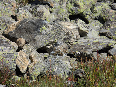
No flowers, but ptarmigan!
The numbers for those who care....
Beginning Elevation: ~9,600 feet
High Point: 11,979 feet
Total climbing and descending: ~ 4,100 feet
Mileage: ~8 miles roundtrip
Other People Factor: moderate to minimal
Time: 2 - 4 hours depending on how often you stop to enjoy the views...
Saturday, August 7, 2010
Mountain Running Parry Peak, Mount Bancroft, and James Peak: Quiet Trifecta on the Continental Divide
Mountain Running Parry Peak, Mount Bancroft, and James Peak: Quiet Trifecta On The Continental Divide
The other day we went out to do another link-up of peaks in the Colorado Rockies. Setting out for a good mountain run with both on-trail and off-trail terrain is always exciting. The Parry/Bancroft/James link-up is a perfect example. With some 4wd road to start, some nice single-track to end, and a bunch of off-trail terrain in between this is another classic - and it is on the Continental Divide so the views and position are spectacular.

Tara on the run up, Alice is down and in the distance...
To do the link-up, drive up to St. Mary's Glacier and turn off at the town of Alice for the Loch Lomond trail and lakes. You can drive up this road for 2 miles to Loch Lomond proper, but we decided to park early to get in a little more mileage - and save our car's shocks!
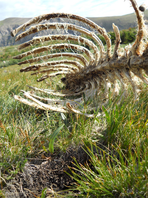
Elk carcass on Bancroft's slopes...
Run up the road to Loch Lomond - as you reach the Loch you can begin to orient yourself - Parry (13,391 feet) is on your far left, Bancroft (13,250 feet) is straight ahead, and James (13,294 feet) is back and to your right. At the Loch, there is a closed jeep road that quickly turns into a trail on the west side right before the dam. Take this as it will get you onto Bancroft's southeast ridge. Follow this up for 2,000 feet keeping to your left as you go up. This will put you just below Bancroft's summit proper, and allow you to cruz over and tag Parry's summit. From here, follow the ridge - Continental Divide - back north over Bancroft's summit and then down into the saddle between Bancroft and James' east slopes.

Tara on Bancroft - Parry in the background...
Once in the saddle, pick your way up onto James' east slopes, tag the summit, and then follow the single-track trail as you run back down through Jamaica Plateau. Keep your eye on the Loch below as you stay on the righthand side - there is a trail that you can pick up and which will drop you right onto the far side of the dam at the base of Loch Lomond. From here, run the road back the 2 miles to your car. On this day it took us 3 hours and 39 minutes.

James Peak - the final peak of the day from Bancroft...

On James, ready to head back down...

And of course, flowers...
The numbers for those who care....
Beginning Elevation: ~10,600 feet
High Point: 13,391 feet
Total climbing and descending: ~ 6,200 feet
Mileage: ~9 miles roundtrip from the Alice
Other People Factor: minimal
Time: 3 - 5 hours depending on how often you stop to enjoy the views...
Sunday, August 1, 2010
Mountain Trail Running Hassell Peak: Excellent Alpine Single-Track
Mountain Trail Running Hassell Peak: Excellent Alpine Single-Track


The other week Tara and I headed up to run Hassell Peak (13,215 feet). Although one starts out at the overly popular Herman Gulch trail head along I-70, trail running up Hassell Peak is really a remote, quite run that takes you through two beautiful alpine valleys.

Looking towards the saddle between Woods Creek and Herman Gulch...
The initial climb is a calf-buster, but after about 1 mile and close to 700 feet of vertical gain, you enter Herman Gulch proper. This is a gorgeous alpine valley with spectacular wildflowers and vistas. Most people that are on this trail are heading towards Herman Lake - a fun run in its own right at ~7 miles - but for this run you don't quite go to the lake. Rather, about .5 miles before you reach the lake, after your final steep climb a junction appears in the trail, with the option to head east over to Woods Creek. Take this junction, head around as you cross over a saddle and then wind your way along the edge of Woods Creek Valley.

Hassell Peak from the saddle of Woods Creek and the broad southeastern slope...
Here is where you will lose all people and have the rest of the run to yourself. You will also be able to see your objective from here, as the trail winds it's way around the edge of Woods Creek Valley and onto the broad south slopes of Hassell Peak.

Tara running the alpine single-track...
Prepare yourself, because the climb up the broad southern slopes of Hassell Peak is long and steep. Work you way up, eventually reaching the Continental Divide just shy of Hassell's true summit. Make a quick tag of the summit, and then follow your footsteps back to the car. While you are up there, you can also scope out several fun link-ups (Jones Pass to Loveland Pass is the best and easiest). On this day it took us 2 hours and 41 mintues.

From the top of Hassell Peak...


The numbers for those who care....
Beginning Elevation: ~10,200 feet
High Point: 13,215 feet
Total climbing and descending: ~ 6,000 feet
Mileage: ~10 miles roundtrip from the Herman Gulch trailhead
Other People Factor: moderate (weekdays) to extreme (weekends)
Time: 2 - 4 hours depending on how often you stop to enjoy the views...
Tuesday, July 20, 2010
The Mount Flora Trifecta: Colorado Mines Peak, Mount Flora, and Breckenridge Peak
The Mount Flora Trifecta: Colorado Mines Peak, Mount Flora, and Breckenridge Peak


One of the easier mountain trail runs found near Colorado's front range is the Mount Flora run from Berthoud Pass. At 3.6 miles and only 2,200 feet of elevation gain, this is a popular one for trail runners to test out their mountain lungs.

On top of Colorado Mines Peak thinking about the next two...
However, when doing this run, it makes more sense to go for the full trifecta - Colorado Mines Peak, Mount Flora, and Breckenridge Peak. The run starts out fairly straight forward - park at the top of Berthoud Pass and run the closed road that leads to the top of Colorado Mines Peak (12,497 feet). After around 1.5 miles you will reach the top. Enjoy the views and the sound of the wind howling through the various antenna and scientific instruments around you.

On Mount Flora... a little windy today...
From here, run down the ridge to your east to reconnect with the main Mount Flora trail. Run this trail as it winds along the ridge for another 1.5 miles to the top of Mount Flora (13,146 feet). Spectacular views await!

View from Mount Flora of Colorado Mines Peak (Peak 1) and Breckenridge Peak (Peak 3)
Now, for the final peak to complete the trifecta. Run back along the trail like you are heading back to the car, but at the first saddle encountered on your WAY BACK (not the lowest point which is where Colorado Mines Peak meets the trail), drop off the south side onto the saddle between the ridge and Breckenridge Peak. Run this ridge keeping slightly left(west) as you wind your way up to the top of the stand-along Breckenridge Peak (12,889 feet).

Tara running back before Breckenridge Peak...
From here, you retrace your steps back to the Mount Flora trail, and then cruz down the casual 2 miles back to your car at Berthoud Pass. All in all, this is an excellent trail run in the mountains, with some climbing but also some really nice stretches of rolling terrain. On this day it took us 2 hours and 35 minutes to do all three peaks car-to-car.

Tara on Breckenridge Peak, Mount Flora is in the far right out of the picture...
The numbers for those who care....
Beginning Elevation: ~11,000 feet
High Point: 13,146 feet
Total climbing and descending: ~ 4,000 feet
Mileage: 10 miles round trip
Other People Factor: moderate.
Time: 2-4 hours depending on how often you stop to enjoy the views...

Running back; Mount Flora (Peak 2) is in the background...

And of course, flowers!
Thursday, July 15, 2010
Mountain Running the Vasquez Mountains: The Grand Loop
Mountain Running the Vasquez Mountains: The Grand Loop


Running mountain loops is always one of my favorite ways to spend time in the mountains. In Colorado we are blessed with the ability to string together several peaks in one go, often via nice mellow ridges that afford spectacular runs in wild country. The Vasquez Mountains Grand Loop is just that. With hardly any traffic, spectacular views, and lots of open tundra running the Vasquez Mountains Grand Loop is always a pleasure. The best part is that the biggest climb of the day is the one you do first, after that there are only a few sections of minor elevation gain, with lots of rolling ridge country to run across.

Tara on the steep beginning section...
Park at the winter trail head for Jones Pass (in the summer, you can drive up the Jones Pass road, but that is not what we are doing). From here, there is a trail heading due north that switchbacks up the southern slopes of an unnamed 12,900 foot peak. After a couple switchbacks and right at treeline, you head off trail and go straight up. This is the steepest part of the mountain run, and is more like a speed hike from hell. Keep going as you gain close to 1,000 feet in elevation until you reach the unnamed 12,900 foot summit. From here, just a quick ridge run away is Vasquez Peak (12,947) to the north. You can see Berthoud Pass to the east. From Vasquez Peak head due west as you drop way down to a saddle where you will cross the Continental Divide Trail. This is the steepest descent of the entire route. Rest, and then head due west on the ridge as you cross over Point 12,316 and eventually hit Mount Nystrom (12,652). From here, you can begin to finally see the finish line. Head due south along the ridge and towards Jones Pass. Cross over Point 12,673 and then the final Bobtail Peak (12,803). From here, jump down and cruz back on the road for about 2 miles until you reach your car (and hopefully a nice stashed beer).

On Peak 1 (12,900) looking at Vasquez Peak (Peak 2)
This is a spectacular loop that connects almost all of the peaks in the Vasquez Mountains. Hardly anyone runs these peaks, let alone the entire loop, so you are sure to have the entire adventure to yourself. The flowers on these slopes are some of the best in the State, and the views of the Grand Valley, Gore Range, Indian Peaks, and beyond are worth every step. On this trip it took us 3 hours and 57 minutes.

Looking at Peaks 3 (Mt. Nystrom) and Peak 4 - route in red dots...


The numbers for those who care....
Beginning Elevation: ~10,100 feet
High Point: 12,947 feet
Total climbing and descending: ~ 6,000 feet
Mileage: ~12 miles
Other People Factor: minimal; I've done this run over a dozen times and have only encountered 3 parties on it (on a Sunday no less).
Time: 3.5-6 hours depending on how often you stop to enjoy the views...
Monday, July 5, 2010
Heartbeat Mountain via Rogers Pass and Heart Lake
Heartbeat Mountain via Rogers Pass And Heart Lake to Rollins Pass and Forest Lakes: Alternative High Lonesome Loop


And of course, flowers...
One of my favorite mountain trail runs near Boulder is the Heart Lake/Rogers Pass run. Starting at the Moffat Tunnel/East Portal, the run consists of 5 miles of shaded single-track that gently climbs along the south fork of South Boulder Creek. After passing Rogers Pass Lake and then Heart Lake, the final climb up to Rogers Pass is well worth it as the views from the Continental Divide always bring a sense of awe and wonder. However, this is only a 10 mile out-and-back, and if you want to tack on a little more, you can continue your run north along the Divide to Heartbeat Mountain. Not many people go here, so you are almost guaranteed a solo peak ascent.

Tara cruzen...
If you want to do even a little more, just keep going north on the Continental Divide over several more "bumps" until you reach Rollins Pass. From here, you can drop onto the Rollins Pass Road, run it back down until you get to the first big U-turn. Here you will encounter the Forest Lakes Trail. Jump on this and take it back down as it passes Forest Lakes and then winds south, eventually connecting with your original trail about 1.5 miles from the Tunnel. A sweet loop that allows you to spend a good amount of time up high, and the bonus is that you are likely to see only a few people at the trail heads. This run is very similar to the popular High Lonesome Loop, but without any of the people. We ran this loop last week and I encountered only 4 people (2 parties)! Try that on the High Lonesome!

The "self-portrait" on Heartbeat Mountain
The numbers for those who care....
Beginning Elevation: ~9,200 feet
High Point: ~12,200 feet
Total climbing and descending: ~ 7,500 feet
Mileage: ~18 miles roundtrip from the Moffat Tunnel
Other People Factor: moderate to minimal
Time: 3 - 6 hours depending on how often you stop to enjoy the views...

Just run the Divide up and over the "bumps"....

And of course, flowers...
Saturday, June 12, 2010
Trail Running with Wild Horses: Miles of Canyon Singletrack in Colorado
Trail Running With Wild Horses: Miles Of Canyon Singletrack In Colorado


Running desert canyons is always an amazing time. Grand vistas, desert scrub growth, sandy trails - trail running desert canyons has it all. And thanks to a little discovery I made, it now also has wild horses! Yep, on the western slope of Colorado resides over 36,000 acres of public land that have been set aside as a wild horse preserve. With no cars or mountain bikes allowed, the beautiful singletrack trails are perfect for trail running.

The Wild Horses checking me out...
There are miles and miles of remote, empty, desert trails for one to run on in the Little Book Cliffs Wild Horse Area, so pick your fancy. Remember, however, that this is remote desert country. There is no to little water, the trails are rocky and very steep in some areas, the trails are poorly marked, and there are no people - so make sure you have some really good trail and route-finding skills. It is easy to get lost here!

Looking down into the Main Canyon
From the parking area, the main set of trails is found by going through the gate and up and over a small hill. From the top of the hill, you will be looking down into the Main Canyon. Orient yourself, because things can get tricky from here. The "trail" drops into the main canyon and then heads north. However, because this is a wild horse preserve, there are hundreds of horse trails that wander in between the willows and desert scrub. The main thing to keep in mind is that the main trail stays in the Main Canyon. The Spring Creek trail is really good, and VERY steep. It runs for 5 miles one way and gains several hundred feet as it winds its way up Spring Creek and eventually connects to the Hoodoo Trail. There is a great loop combining the Coal Creek trail with the Hoodoo Trail with Spring Creek. They say it is 14 miles, but it will feel like 20.

The trail signs... hard to follow with all the horse trails around...
If you want to keep going, stay in the Main Canyon and follow it for another 4 miles until you get to the Cottonwood Canyon trail. This is another excellent trail running west up Cottonwood Creek as it climbs up to the mesas.
Either way, this is one of the ONLY places in the United States where you can run with wild horses. It is a must on any trail runners agenda. The adventure level is high because of the remote setting and lack of clearly marked trails, as well as the added bonus of running along side a herd of wild horses.

Cool rock formations... lots of boulders for the boulderer...
The numbers for those who care....
Beginning Elevation: ~5,000 feet
High Point: ~6,400 feet
Total climbing and descending: ~3,000 feet
Mileage: ~8-20 miles roundtrip
Other People Factor: none
Time: 2-5 hours depending on how often you stop to enjoy the views...

Looking back down Spring Canyon... the "trail" is in the scrub somewhere...


The wild horses hanging out...

What would a run be without desert flowers?
Subscribe to:
Posts (Atom)