Friday, May 29, 2009

The Gutter: Endurance Training on the Second Flatiron

I've been doing a bit of endurance training this spring. Not only in terms of trail running, but also for climbing. Over the winter, bouldering dominates with short, powerful moves. However, now I'm trying to get back into alpine shape for the upcoming season, and to do that I have been doing laps at the Gutter.

Located up on the Second Flatiron, the Gutter is an excellent place to build up strength and endurance. At ~80 feet long, this forearm pumping problem will get you breathing hard and searching for your chalk bag in no time. With two cruxes, some real good rests, and a steep, sustained overhang the gutter is one of my favorite places in the spring.
Bouldering at the Gutter on the Second Flatiron
The last time we were there I tried to get a couple pictures, but the place is hard to photograph. As you can tell from the only one that "kinda" turned out, the gutter is a slot that you can either climb "in" or on the "lip" for a range of 12b to 13a roughly.

Shady in the afternoon, I'll probably hit the place up a couple more times before it gets to hot and the higher stuff opens up.

Saturday, May 23, 2009

Boulder Skyline Traverse Trail Run: All the Peaks

In another attempt to get our legs into full mountain running shape, Tara and I decided to hit the Boulder Skyline Traverse. This is perhaps one of the most classic trail running traverse routes along the Colorado front range, and will easily test the leg endurance of any avid trail runner.
Tara running the Boulder Skyline Traverse
The objective is easy: traverse all of the peaks along the Boulder skyline from Boulder Canyon to Eldorado Canyon. This includes Flagstaff, Green Mountain, Bear Mountain, and South Boulder Peak.

The method: Getting a late start (10:20ish AM), we parked the car at Chautaqua and started up the Flagstaff Trail. From the top of Flagstaff, you cruz over to Green Mountain and run up the Saddle Rock/E.M. Greenman trail to the top. From there, you drop down the west side on the Green Bear trail and pick up the Bear Peak West Ridge trail to the summit of Bear. From there, you can traverse south and over to South Boulder Peak. We opted to go back over Bear and down Fern Canyon, then run the Mesa Trail back to the car. Some like to have a second car parked at Eldorado so they don't have to make it an entire loop, but I prefer doing the entire loop.
Bear Peak lost in the distance
The scene: The day started off cold and cloudy. We thought it was going to rain; little did we know that by the end of the run it would be blue skies and sunshine. The only people we encountered were on the summit of Bear and on the way down Fern. Otherwise, it was an amazing way to see the city of Boulder and the plains beyond as you run over 5 peaks in a spectacular setting.
Boulder Skyline Traverse Trail Run
The Stats: As with most trail runs, the numbers don't do it justice. From what I can gather, the route we did is only around 12 miles and 6,000 feet of climbing. Your quads will think you did double...

Monday, May 18, 2009

Mid-Winter Laps: Telemark Skiing Switch, Jumps, and Backcountry Video

Well, today we hit the high 80s mark on the thermometer. That means the spring snowpack is going to melt out really fast again this spring. Seems to be happening more and more: we get a good snow pack built up in March and April to only have it melt out by the end of May. Growing up I remember when it would last well into June and sometimes even into July. No worries, just means a longer season running peaks...

However, in honor (or remembrance) of this past winter, we put together another fun little telemark video of some highlights from the season. Nothing spectacular, but I think the film goes well with the sound. If nothing else, this video will keep the snow stoke going through those hot summer days to come.


It has all the usual antics: switch, 180 switch, backcountry telemarking, and some drops and jumps. Let's hope this summer is not a roaster like last year...

Thursday, May 14, 2009

Early Season High Altitude Trail Running: Rollins Pass Road

We went up to see how the trails were melting out and how the high-altitude running was shaping up for the season. Although it is a little early, along the Colorado front range there are some spots that melt out early and allow you to get in some excellent high-altitude running.
Snow blocking access to the road
We thought we would check out the Tolland Road (also called Mammoth Gulch Road), as that is often melted out early and allows for some good elevation gain: going from ~10,000 up to ~12,00 at Kingston Peak. However, there was still a little too much snow to get any real distance in, so we opted for Plan B: Rollins Pass Road.

Now, this is usually not my favorite, as high clearance cars are allowed to drive on this in the summer (although there are several spots now that require 4-wheel drive to navigate), but we wanted to get in some high-altitude miles on our legs and lungs. Luckily, the road was still blocked at the beginning by a huge snowbank, so there was no one on it.
Tara running Rollins Pass road for Colorado altitude training
The road gently climbs for around 10 miles one way, allowing you to really put in some good distance above 10,000 feet. Currently there are two large snow sections that you have to cross, but otherwise the running was dry and clear.

Often overlooked, Rollins Pass Road is one of the better early season mountain training spots along the Boulder front range area. Close to town, good distances, nice altitude, and fabulous views make this spot an excellent place to get in some early season high-altitude miles. We put in 15+ miles above 10,000 feet. Just warming up for another summer mountain running season.
Beautiful Rollins Pass valley in Colorado

Saturday, May 9, 2009

Tick Free Bouldering: Climbing Without Ticks in Boulder

It's tick season here along the Colorado Frontrange. These little buggers bother the hell out of me and they always make for an unpleasant climbing session. They can be found all over the Flatirons, Boulder Canyon, Clear Creek Canyon, and Eldorado. However, there are a few places that one can go and still get in some really great climbing without the fear of finding ticks later that day in the shower.
Hidden bouldering on Dinosaur Mountain
The Satellites are tick free (although there seem to be more and more people there all the time), the Gutter is free of them, and so is most of the stuff on Dinosaur Mountain. Therefore, while waiting for the high country to melt out, Tara and I have been hitting the Gutter and Dinosaur Mountain a fair amount.

The Gutter is a great endurance problem located on the side of the Second Flatiron. I've been climbing here for almost 10 years, and I can still get a solid pump on the problem. My current favorite is to do the low version up, rest at the top, and then downclimb the high version. That is over 160 feet of solid climbing at 12c or above. Not bad for a little session.
Dinosaur Mountain bouldering
The Dinosaur Mountain stuff is different. You can either do some of the bouldering right off the trail, hit some of the obscure stuff tucked away in the talus and off on the sides, or try and do the Avs traverse. We have been hitting it all up, finding a few new gems and getting very close to sending the Avs Wall. Yesterday I fell off the last move before getting to the final rest - at which point there are still 20 feet of climbing left. The temps were hot - I'll blame it on that.

Sure hope those ticks go away soon so the other areas open up.

Sunday, May 3, 2009

Trail Running South Boulder Peak Via Shadow Canyon: Getting Read for the Mountain Running Season

One of the best trail runs around the Boulder area for getting in strong mountain running shape is the Shadow Canyon trail up to the top of South Boulder Peak. With a vertical gain of close to 3,000 feet, this run will get your legs and lungs in shape for a solid season of mountain running. I've been running this trail once a week for the last couple of weeks to get in shape, tagging both South Boulder Peak and Bear Peak in the process. Depending on the legs, I usually either drop back down Shadow Canyon or off the top of Bear Peak down Fern Canyon, then back along the Mesa Trail to the trailhead. As the snow melts out up high, this run gets you ready for some long days and steep trails, plus it gives you a view of the Continental Divide so you can check conditions. To get psyched, I've posted a couple photos from last seasons mountain runs...
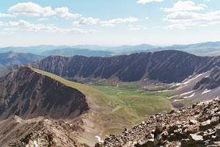
Trail Description

The challenging trail run to South Boulder Peak rewards visitors with unparalleled 360-degree views of the eastern plains, Boulder's front and back ranges, the Indian Peaks and Continental Divide. Boulder's extensive trail network allows for several routing options: the following describes the Homestead-Shadow Canyon-Bear Peak West Ridge route, and is highly recommended for its beautiful scenery, difficulty, and lighter trail traffic.
Tara mountain running outside of Leadville Colorado
From the South Mesa Trailhead parking lot, cross over the footbridge and follow signs to the Homestead Trail (.1 mile) - bear left. The Homestead Trail rises quickly up through the initial mesa climb, then gradually climbs through open treed slopes.

The Towhee Trail merges with the Homestead Trail after 1.35 miles, and then shortly after merges with the Shadow Canyon Trail. The Shadow Canyon Trail joins a fire road at this point (6,275). Turn left on the fire road and climb methodically over well-groomed terrain for .7 miles to the last Mesa Trail access point, and beginning of travel up Shadow Canyon (2.1 miles : 6,582).

Here the trail is considerably more strenuous, climbing 1,967 in just 1.25 miles to reach the summit. Lingering winter conditions will amplify this challenge. The trail twists and weaves tightly along a faintly marked path amid notably large boulders and old-growth ponderosa and lodgepole. Look for occasional signs posted on trees to the right of the trail for guidance. Though views are limited, the dark, boulder-laden forest itself is quite scenic and serene.
Typical view from a Colorado mountain trail run
The grade eases upon reaching the Shadow Canyon Trail - Bear Peak West Ridge Trail junction (3 miles : 8,155). Take note of young aspen groves on the saddle before turning left (south) for the last .35 miles to South Boulder Peak. The final 100 yards run up a steep scree field; extra caution is necessary when snow, ice or strong winds are present.

The summit is small and pointed, but the large boulders comprising it afford ample room for a handful of visitors to find small nooks with sensational panoramas.