Wednesday, December 31, 2008
Backcountry Telemark Skinning: Video and Trip Report
Last week Tara and I skinned up Grizzly Gulch to the southeast side of Grizzly Peak (here is a little trip report plus video from the backcountry outing). Well, we finally got around to putting the telemark footage to music and editing it. Below is a little video from that backcountry trip. As you will note, there was quite a bit of wind up high (classic Colorado conditions), and hopefully we captured it.
Today, as a way of ringing in the New Year and saying googbye to 2008, we skinned in to the base of the north side of James Peak (13,294). Again, there was some wind blowing - short gusts filled with wicked micro-snow crystals. However, just down below treeline the conditions were really pleasant, and the snow was deep and soft. Perfect for making some smooth, arching tele turns in deep powder. We got a little footage of the backcountry day, and hopefully I'll post it soon. Until then, enjoy the movie. If you want, you can also check out this other telemark video we recently did. I'd love to hear feedback...
Sunday, December 28, 2008
Christmas Day Bouldering in the Flatirons: Above Shadow Canyon
Christmas time in Boulder can always be a little strange. Although it was dumping all week in the mountains (providing excellent telemark conditions), none of the storms made it over the Divide and onto the Front Range. This often happens during the winter. A storm will get stopped by the mountains and just sit up on the Divide, leaving us with cold temps, sunny or semi-sunny days, and a fair amount of wind.
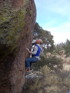
This past week was no exception. Vail Pass and areas west got several feet of snow, while here in Boulder the snow from the week before stuck around despite the mellow conditions. On Christmas, as we had too many family obligations to get away, Tara and I hiked up to the base of Shadow Canyon to get in some climbing outside. Because of the cold temps (nights have been in the teens, days in the twenties to thirties), most of the projects I've been interested in were a no go - they are in the trees or shade and just would be to cold. However, there are walls in the Flatirons that you can climb on all year, no matter what the temps. They face south, have good exposure, are wind protected, and allow for a really fun session. The following two pictures are from Christmas Day, high up in the mini-flatirons above Shadow Canyon.


Although not stellar photos, it is always a pleasure to get outside. Did anyone else get out Christmas Day? Happy Holidays to everyone.
Tuesday, December 23, 2008
Fell Running: Mountain Running British Style
I've always wanted to try my hand at Fell Running. During the summers I do a ton of mountain running here in Colorado and the Rocky Mountains, but have yet to make it over the Atlantic to give Fell Running a try. It seems like a natural progression, as mostly the mountain running I do in the summer is of a similar nature. Last summer Tara and I did over 50 peaks in the area, all in a light weight, speed oriented fashion similar to Fell Running.

In that vein, I found this article on Fell Running to be interesting. Perhaps next year I'll make it over to give it a try...
I have never felt so unfit in my life. We are only 10 minutes from the car park and my heart is hammering, my thigh muscles screaming, as I try to keep up with the lean, agile figure on the trail in front of me. “This pace OK?” calls Angela Mudge over her shoulder, not remotely out of breath. “Er, fine,” I gasp, wondering if my lungs might collapse at any moment.
Mudge is to fell running (hill running, if you’re in Scotland) what Paula Radcliffe is to road running. Last December, she knocked 13 minutes off the Mount Everest marathon course record – a 42km race that begins at an altitude of more than 17,000ft and entails a 16-day trek to the start. This year, she won the British Fell Running Championships for the fifth time.
Rather rashly, I suggested we do a hill run together. Which is how I find myself, one bright, clear but achingly cold morning, in Rowardennan car park on the eastern shore of Loch Lomond, preparing to run up a 3,200ft mountain with arguably the best female hill runner in the world.
I feel nervous and overburdened as I pack my rucksack – heart-rate monitor, gloves, isotonic sports drink, jelly babies. Mudge simply carries an extra layer and a waterproof jacket. “I don’t do technology,” she says. “If you’ve been running long enough, you know when you’re running hard, when you’re running easy. I don’t need to be scientific about it.” Doesn’t she carry fluid? “Not on the hills. I just drink from the streams. I’ve never got into the habit of using sports drinks.” For all my gear, it transpires that my Gore-Tex trainers aren’t up to the job. Luckily Mudge has a spare pair of size seven fell running shoes, which I dutifully put on.

We head off through the trees, and almost immediately begin to climb. “Take short, fast strides and stay on your toes,” instructs Mudge, climbing nimbly like a mountain goat. The path up Ben Lomond is one she has run countless times, as have her two Jack Russells, Canna and Arkle, who are zipping back and forth between us, covering twice the distance. In fact, Mudge has run up all 284 Scottish Munros (mountains over 3,000ft). “This one is a hard climb, but the terrain isn’t bad, so you can keep up some leg speed,” she says.
Now, I’m not what you’d call unfit. I’ve run 14 marathons (best time three hours, 22 minutes) and I run four to five times a week. But my heart rate is already 169 beats per minute. Once we’re clear of the forest, a section of steep rock, slick with water, slows me to a walking pace. “You should walk at a certain gradient,” reassures Mudge. “It’s faster, and it uses your muscles differently, so gives them a break.” She shows me the “fell runner’s walk”, bending over from the waist and taking large steps, with hands on knees to help push yourself onwards and upwards.
Read the rest of the article on Fell Running here.
Friday, December 19, 2008
Another Long Telemark Run: Ski Movie About Going Up and Down
Well, the snow has finally been falling here in Colorado, and the backcountry has begun to open up. On Wednesday Tara and I skinned up Grizzly Gulch all the way to the base of the southeast side of Grizzly Peak (13,427 feet). Grizzly is a spectacular 13er, and this little backcountry spot often gets overlooked for areas just a little further up I-70. Perhaps one of the reasons many telemarkers skip over the valley is because it is about 5 miles of skinning before you even begin to approach the fun stuff.
We skinned in and found the snow to be quite good. The road is covered all the way to where the trail starts and breaks away from the summer Grays and Torreys trailhead. Skinning around the north side of Torreys Peak (14,267 feet) is great, through meadows and forested slopes. You get a bunch of really good views of Torreys' North Face with the two large snow couloirs descending the entire face. The further in is an amazing telemark descent in the spring, but for now we passed it to hit some of the lesser known chutes coming off of Grizzly Peak's southeast face.
There is plenty of snow up high, most of the rocks are covered, and a descent base has formed. As always, one has to know what they are doing and watch the conditions for avalanches, but it looks like the Colorado backcountry has opened for telemark skiing. To hold you over until I get the footage sorted out from the trip, here is a new video called Another Long Telemark Run. Enjoy, and if you care, share your thoughts.
Tuesday, December 16, 2008
The History of Skiing: New Books Gives Comprehensive History
My father-in-law is a ski history nut. He can name nearly every World Cup downhill champion of the past 30 years. On his living room bookshelf you will find copies of Ski Racing magazine stretching back to the early 1980s.
The man is going to love Two Planks and a Passion: The Dramatic History of Skiing, Roland Huntford's history of skiing. It's a deep trove of exactly the kinds of minutiae that will stick in his brain the way baseball statistics stick in mine. For the rest of us, though, Two Planks and a Passionis the sort of facts-and-dates history that keeps us from reading, well, history.

In his earlier books, Huntford chronicled the race to the South Pole (The Last Place on Earth ) and wrote biographies of Ernest Shackleton and Fridtjof Nansen. Two Planks and a Passionseems a natural progression for him. After all, hearty dogs and good skis made the difference for Roald Amundsen in his bid for the South Pole. But the earlier books were filled with tales of derring-do, and Two Planks and a Passionseems overwhelmed by Huntford's research. Somewhere along the way he abandoned his duty to include gripping stories and just started packing in trivia.
That's a shame, because there's great material here. For instance:
Huntford reproduces a 4,000-year-old rock drawing from Russia that depicts three Stone Age hunters on skis stalking elk. It's an astonishing image, like seeing a stick figure on a Jet Ski in the caves of Lascaux.
"To prehistoric northern man, the ski was an instrument of survival," Huntford writes. "He needed good sliding, preferably without any slip on the kickoff, to overtake his prey."
In the ancient world, the ski was known across Northern Europe and Asia - though not North America, curiously - and the Lapps and the Norse were the acknowledged masters of the pursuit.
Read more on the History of Skiing here.
The man is going to love Two Planks and a Passion: The Dramatic History of Skiing,

In his earlier books, Huntford chronicled the race to the South Pole (The Last Place on Earth
That's a shame, because there's great material here. For instance:
- The ski predates the wheel.
- The earliest known fragments, circa 6000 B.C., come from northern Russia, and archaeologists have unearthed evidence of skiing in Norway, Sweden and Finland dated to 3200 B.C.
Huntford reproduces a 4,000-year-old rock drawing from Russia that depicts three Stone Age hunters on skis stalking elk. It's an astonishing image, like seeing a stick figure on a Jet Ski in the caves of Lascaux.
"To prehistoric northern man, the ski was an instrument of survival," Huntford writes. "He needed good sliding, preferably without any slip on the kickoff, to overtake his prey."
In the ancient world, the ski was known across Northern Europe and Asia - though not North America, curiously - and the Lapps and the Norse were the acknowledged masters of the pursuit.
Read more on the History of Skiing here.
Friday, December 12, 2008
XTERRA Trail Running World Championships in Oahu, Hawaii
The XTERRA Trail Running World Championships just held their first race, and it looks like Max King and Cynthia Anderson took away top honors.
Max King, 28, from Bend, Ore. and Cynthia Anderson, 25, from Kailua, Hawaii won the inaugural XTERRA Trail Running World Championship half-marathon at Kualoa Ranch on Oahu on Sunday morning. More than 800 runners from 32 states and eight countries participated in the 5K, 10K and 13.1 mile events.
Near perfect running conditions with cool breezes, cloud cover and temperatures in the mid-70s greeted runners for the half-marathon championship race that featured 3,000 feet of elevation gain while weaving up-and-down the verdant cliff faces in Ka'a'awa Valley and into the dense rainforest of Hakipu`u Valley at Kualoa Ranch.

King, a member of the Team USA cross country squad and the reigning XTERRA Trail Running USA Champ, led from start-to-finish and was the only runner to post sub 6-minute miles for a winning time of 1 hour, 18 seconds, 24 seconds. Ben Bruce of Eugene, Ore. finished more than three minutes back in second place at 1:21:56, and Thomas Taylor of Phoenix, Ariz. placed third in 1:29:34. Honolulu's Matt Stevens was the top local finisher just 17 seconds later.
"Ben (Bruce) is as good a runner as I am, and I am always afraid of him," said King. "This race was a lot tougher than Nationals. The last 5 kilometers were definitely the most challenging. I just didn't want to do anymore hills. This was an awesome event."
His first time in Hawaii, Bruce said this terrain, and the course's elevation gain was quite different than what he is used to. "There was more climbing in the first two miles of this race than the entire Nationals race combined."
Read more about the Inaugural XTERRA Trail Running World Championship here. For other trail races a good place to start is the Trail Runner calendar. Happy trails.
Monday, December 8, 2008
San Luis Valley Bouldering: Problems Galore in Colorado and New Mexico
So I'm adding some pictures of the bouldering down in the San Luis Valley and northern New Mexico. Tara and I go here regularly - lots of good bouldering, secluded, and quality stone are all reasons to make a trip to the Valley. There are several areas that are already known, and ton more waiting to be found or developed. Some of the best places in the Valley include: Boulder City, the Breakfast Boulders, Penitente and Rock Garden area, Rock Creek, Crestone, Orient Mine Wall, Questa Dome boulders, Tres Piedras, the Beach Wall, Cerro Azul, El Rito, Red River bouldering, Hidden Gulch, and many more.
If you are looking for adventurous bouldering in an amazing setting, then perhaps a trip to the Valley is for you. You can climb all year, with some of the best temps occurring from October-March.

Types of Stone: Rhyolite, Granite, and Basalt.
Rest Day Activities: hot springs, mountain biking, trail running, artistic tours, contemplation, excellent New Mexican food.


Saturday, December 6, 2008
Telemark Skiing Above the Arctic Circle: Riksgransen, Sweden
There was a great article in the New York Times the other day about telemark skiing above the Arctic Circle. In Riksgransen, Sweden apparently there is a hardcore group of telemark skiers. Looks like a great place to hit next spring...
The helipad was little more than a flat patch of snow roped off between some parked cars and the hotel. The chopper didn’t inspire confidence, either: it was an ancient-looking craft, with a nearly 50-year-old fuselage and a crack in the bubble windshield. But this lawn dart, I was assured, was a gem — an Alouette III, the classic French mountain helicopter. After some perfunctory instruction by the mountain guide, we climbed aboard and belted in. Blades Cuisinarted the air. Seats shook. Two guys taking off their ski boots next to the helipad ducked for cover. Then we were hammering south into empty mountains.

When the helicopter shut down the rotor atop 5,209-foot Vouitasrita, the silence poured in to fill the void. Our mountain guide waved a pole south across a horizon of white breakers. “More or less everything you see here, we can heli-ski,” he said — all the way to the Finland border, to the east. The summit of 6,926-foot Kebnekaise, Sweden’s highest mountain, nosed for prominence on the southern horizon.
This was an April evening in the land of the midnight sun.
There’s an understanding among Scandinavia’s diehard skiers: when the weather turns warm, it’s time to finish off the season at the world’s northernmost ski resort. There, at Riksgransen, more than 130 miles above the Arctic Circle in Sweden, the skiing isn’t over until that midnight sun finally droops below the horizon.
“It’s become a bit of a legendary place for the Swedes,” explained Torkel Karoliussen, a champion Norwegian telemark skier who has visited Riksgransen more than a dozen times. “The season doesn’t really start until March, and it’s best in May, and you can ski under the midnight sun in June.”
It’s true: starting about May 10 each year, the lifts close at 4 p.m. — only to reopen (on weekends) from 10 p.m. until 1 a.m.
Read the rest of the article about telemark skiing above the Arctic Circle here.
Wednesday, December 3, 2008
Late High Altitude Trail Run: The Salt Creek Trail (618) in South Park, Colorado
Last week we went down into the San Luis Valley and Northern New Mexico to climb at a couple new areas that are being developed, and to get in a final high altitude trail run before the snows closed up the high country. As this fall and winter have been really dry (until the weekend after Thanksgiving when Loveland got 60 inches), a lot of the high country trails have remained open.
Running single-track is always such a pleasure, but running single-track trails well after the season normally closes is a treat - there is no one out, the temps are always nice, and the forest and wildlife have settled into their more somber and quiet winter state. Taking advantage of this, Tara and I decided to run the Salt Creek Trail (#618) and its various off-shoots.

There are several access points onto this trail.
We came in from the last of these options, taking the Fourmile Drainage from Trout Creek Pass and ran north.
View Larger Map
As you can see from the map, the terrain is quite nice. Rolling hills in a quiet forest setting for about 15 miles one way. You can eventually take trail #618 all the way to the northern terminus (Lynch Creek Trailhead on Forest Road 431), at which point you are able to connect to the Rough and Tumbling Trail (#617). It is possible to take #617 around to the north and west of West Buffalo Peak and down towards Forest Road 375 (Fourmile Road) and then back to your starting point for a grand circumnavigation trail run of East and West Buffalo Peaks.
Total distance is 35+ miles all on single-track or closed Forest Service roads. This is one of the better, longer single-track trail runs found in the Colorado Rocky Mountains. Perfect for fall or even summer, as much of the run is above 10,000 feet and in the trees.
If you don't want to do the entire 35+ mile loop, as it requires some planning, the Salt Creek Trail (618) is a worthy trail run on its own.
Difficulty: Easy to Moderate
Elevation Gain: 2,250 Feet (701.4 Meters)
High Point: 11,100 Feet (3460.1 Meters)
Length, One-way: 15.5 Miles (25.83 Kilometers)
Usage: Moderate
USGS Maps: Marmot Peak and Jones Hill
Running single-track is always such a pleasure, but running single-track trails well after the season normally closes is a treat - there is no one out, the temps are always nice, and the forest and wildlife have settled into their more somber and quiet winter state. Taking advantage of this, Tara and I decided to run the Salt Creek Trail (#618) and its various off-shoots.

There are several access points onto this trail.
- FDR 435 Brush Park. You can reach this road from US Highway 285. The trailhead is at the end of FDR 435. You can hike either direction on the trail from this location.
- FDR 436 Middle Fork of Salt Creek. You can reach this road from US Highway 285 at the same location. Follow FDR 435 to FDR 436. The trailhead is not as well marked at this location.
- FDR 431 Turn off of US Highway 285 onto the Buffalo Springs Road. The Lynch Creek Trailhead is located at the end of FDR 431. The Salt Creek Trail crosses FDR 431 at several points. Salt Creek Trail can also be accessed from FDR 433, which connects FDR 431 to US Highway 285 via Pony Park. It can also be accessed from Tumbling CreeK trail in the Fourmile Drainage on the Salida Ranger District. Follow County and Forest Service Road 377 from Buena Vista to FDR 375 to its end at the Fourmile Trailhead. This section is not open to mountain biking since it is in the Wilderness Area.
We came in from the last of these options, taking the Fourmile Drainage from Trout Creek Pass and ran north.
View Larger Map
As you can see from the map, the terrain is quite nice. Rolling hills in a quiet forest setting for about 15 miles one way. You can eventually take trail #618 all the way to the northern terminus (Lynch Creek Trailhead on Forest Road 431), at which point you are able to connect to the Rough and Tumbling Trail (#617). It is possible to take #617 around to the north and west of West Buffalo Peak and down towards Forest Road 375 (Fourmile Road) and then back to your starting point for a grand circumnavigation trail run of East and West Buffalo Peaks.

Total distance is 35+ miles all on single-track or closed Forest Service roads. This is one of the better, longer single-track trail runs found in the Colorado Rocky Mountains. Perfect for fall or even summer, as much of the run is above 10,000 feet and in the trees.
If you don't want to do the entire 35+ mile loop, as it requires some planning, the Salt Creek Trail (618) is a worthy trail run on its own.
Difficulty: Easy to Moderate
Elevation Gain: 2,250 Feet (701.4 Meters)
High Point: 11,100 Feet (3460.1 Meters)
Length, One-way: 15.5 Miles (25.83 Kilometers)
Usage: Moderate
USGS Maps: Marmot Peak and Jones Hill
Subscribe to:
Posts (Atom)