More Science is Needed - Altitude Training and Running Performance
Two new articles just published on altitude training and running or exercise performance. The first, entitled "The role of haemoglobin mass on VO2max following normobaric ‘live high–train low’ in endurance-trained athletes" looked at two possible mechanisms that the live high-train low method may have on boosting running performance. The first theory is that living high and training low will help improve maximal oxygen uptake (VO2max) and that this improvement is related to hypoxia-induced increases in total haemoglobin mass. The other contending theory is that living high and training low improves maximal oxygen uptake (VO2max) and that this improvement is related to improved maximal oxidative capacity of skeletal muscle. Surprisingly the authors found that after a 4 week period of living high and training low, athletes showed no improvement in VO2max (they did use elite cyclists rather then elite runners, but one would assume that would not make a difference)! This is also interesting in light of other research that seems to indicate that speed training does boost VO2max. So, why not altitude? Perhaps it is because the subjects/athletes in this study did not perform rigorous training exercises? The jury seems to be still out on this contentious subject.
This is reflected in the second study published recently: "Does ‘altitude training’ increase exercise performance in elite athletes?" Although a review article, it makes a good point in that we really have not investigated altitude training in any comprehensive, scientific way. For example, the scientific gold-standard design of a double-blind, placebo-controlled, cross-over trial has never been conducted on altitude training! So, although people swear by it (including me, although like I've said previously, I do more live high-train high), the scientific research on altitude training is too nascent to come to any positive conclusions. Hopefully this subject will be taken up with more vigor in the coming years.
As for me and my running, I got a new PR on my ~15K loop today with 1:11:40, dropping two minutes off my previous PR. I guess that means its time to add on some new miles to the loop as I would prefer my fast run to take about 1:30.
Wednesday, August 22, 2012

Monday, August 20, 2012
Jones Pass Loop - Time on the Divide
Jones Pass Loop - Time on the Divide
This morning, despite the clouds and threatening rain, I ran the Jones Pass loop. This is an excellent loop that features a fair bit of time on the Continental Divide above 12,000'. Although the loop is only ~14 miles, eight of those miles are above 12,000' and stay directly on the Divide, making this loop a great run for altitude and views. Plus, you get to tag one named peak (Hassell Peak at 13,215') and about 6 unnamed 12,000+ mini-peaks. The loop starts at the winter parking lot near the Henderson Mine at the base of the Jones Pass road. Run up the road, but then take your first left up Butler Gulch. Follow the old, closed mining road up into the Butler Gulch basin until you get to just past treeline. At this point, angle left/south and find a goat trail that will take you up onto the ridge running east off of Hassell Peak. Once on this ridge, run along it until you climb up and eventually reach the Divide. From here, you are on the Continental Divide Trail (perhaps one of the best sections, and one of the longest sections of the trail that is above 12,000'), and a quick jaunt south will take you to the top of Hassell Peak (I've run this a couple times; an alternative is to run Hassell Peak from the Herman Gulch trailhead). From the top of Hassel, simply head north on the Divide. You can either stay on the trail, which skirts the Divide itself, or as I did today, tag all of the little summits along the Divide (about 6 unnamed 12,000' peaks). Keep running north on the Divide past the Jones Pass road, tagging three more mini-peaks before heading east and dropping down along a ridge that splits the West Fork of Clear Creek with Vasquez Creek. The trail drops down, then turns south and angles along the western slopes of Vasquez Peak until connecting up with the trail to Stanley Mountain. At this point, just drop down a couple switchbacks and you are back at the start. Like I said, although this loop is only ~14 miles, it has over 5,256' of elevation gain, so it still packs a punch. It took me 3:23 today, with stops on Hassel and a few other spots for photos. You can go faster if you stay on the actual trail and don't tag all of the mini-summits.


This morning, despite the clouds and threatening rain, I ran the Jones Pass loop. This is an excellent loop that features a fair bit of time on the Continental Divide above 12,000'. Although the loop is only ~14 miles, eight of those miles are above 12,000' and stay directly on the Divide, making this loop a great run for altitude and views. Plus, you get to tag one named peak (Hassell Peak at 13,215') and about 6 unnamed 12,000+ mini-peaks. The loop starts at the winter parking lot near the Henderson Mine at the base of the Jones Pass road. Run up the road, but then take your first left up Butler Gulch. Follow the old, closed mining road up into the Butler Gulch basin until you get to just past treeline. At this point, angle left/south and find a goat trail that will take you up onto the ridge running east off of Hassell Peak. Once on this ridge, run along it until you climb up and eventually reach the Divide. From here, you are on the Continental Divide Trail (perhaps one of the best sections, and one of the longest sections of the trail that is above 12,000'), and a quick jaunt south will take you to the top of Hassell Peak (I've run this a couple times; an alternative is to run Hassell Peak from the Herman Gulch trailhead). From the top of Hassel, simply head north on the Divide. You can either stay on the trail, which skirts the Divide itself, or as I did today, tag all of the little summits along the Divide (about 6 unnamed 12,000' peaks). Keep running north on the Divide past the Jones Pass road, tagging three more mini-peaks before heading east and dropping down along a ridge that splits the West Fork of Clear Creek with Vasquez Creek. The trail drops down, then turns south and angles along the western slopes of Vasquez Peak until connecting up with the trail to Stanley Mountain. At this point, just drop down a couple switchbacks and you are back at the start. Like I said, although this loop is only ~14 miles, it has over 5,256' of elevation gain, so it still packs a punch. It took me 3:23 today, with stops on Hassel and a few other spots for photos. You can go faster if you stay on the actual trail and don't tag all of the mini-summits.


Hassell Peak with the ridge (the other small red dot) that you climb out of Butler Gulch

Looking down on Hassell Lake in the Woods Creek basin

The red dot is where you are going, keeping on the ridge along the entire way

Looking at Pettingell Peak from Hassell

Evans and Bierdstat (in the distance) and Bard, Parnassus, and Woods Peaks in the front (left to right - part of the Ruby Creek Traverse)

Looking back at Hassell Peak after crossing Jones Pass and tagging the first mini-peak

Looking all the way back at Hassell Peak from the last mini-peak before heading down
Thursday, August 16, 2012
Speed Ascent Of St. Louis Peak
Speed Ascent of St. Louis Peak
With only 2.5 hours of time today, I tried to do a fast speed ascent of St. Louis Peak (12,241'). Located in the center of the Vasquez Wilderness, St. Louis Peak is a really nice, seldom visited run that follows the headwaters of St. Louis creek. The haze from the fires in Nevada, Oregon, California, and Washington was pretty bad, as evidenced by the photos, but didn't seem to impact the lungs too much. Fall is hitting the high country fast - with all the heat this summer and lack of rain, most of the plants have started to turn, and a lot of the lodgepole pines are showing evidence of the drought. However, there are still a few flowers out.
The run is 13.8 miles long, with 3,612' of gain. I did it in 2:19:40, which I think is a fairly fast time. I slowed down a bit on the way back to snap some photos of the last flowers of the summer, as well as to hang on the summit to (try) and enjoy the views. I don't know if it is a FKT, but it is a PR for me on the peak and a good baseline to work from.


With only 2.5 hours of time today, I tried to do a fast speed ascent of St. Louis Peak (12,241'). Located in the center of the Vasquez Wilderness, St. Louis Peak is a really nice, seldom visited run that follows the headwaters of St. Louis creek. The haze from the fires in Nevada, Oregon, California, and Washington was pretty bad, as evidenced by the photos, but didn't seem to impact the lungs too much. Fall is hitting the high country fast - with all the heat this summer and lack of rain, most of the plants have started to turn, and a lot of the lodgepole pines are showing evidence of the drought. However, there are still a few flowers out.
The run is 13.8 miles long, with 3,612' of gain. I did it in 2:19:40, which I think is a fairly fast time. I slowed down a bit on the way back to snap some photos of the last flowers of the summer, as well as to hang on the summit to (try) and enjoy the views. I don't know if it is a FKT, but it is a PR for me on the peak and a good baseline to work from.


Looking back down the St. Louis drainage

Looking north at Byers (on the right) and Bills (left)

Looking south into the haze...

Looking east towards the Divide, which is usually in view.

Some of the last flowers for the summer

Wednesday, August 15, 2012
Update and Economy is Not Sacrificed in Ultrarunners
Update and Economy is Not Sacrificed in Ultrarunners
Tuesday: Did the usual 12K loop with 1,700 gain. Still pulled it off in 1:13 but had to work a little harder for it. Legs were a touch sore from Sunday's loop in the mountains.
Today: Ran a quick version of Tipperary to Backscratch then down the road back to Tipparary. Did the loop twice, once each way. It is about 16K with about ~800 gain on each loop. Took 1:18 today.
Interesting letter in the Journal of Applied Physiology published today on running economy in ultrarunners. Basically, looks like the author argues that you cannot compare elite ultrarunners with elite runners in short distances, simply because ultrarunning is still too new of a sport, as well as the large differences in ultra trail events versus more road-based races. It begs the question that lots have been talking about on the net: if the prize money was big enough, would some Kenyans or Ethiopians come over the ultrarunning and just blow the times out of the water? From what I can tell, the author Grégoire P. Millet, from the Universite de Lausanne would argue no. The two types of racing are just too different, especially concerning the hilly or mountainous nature of most trail ultras. Good to know, but with Sage Canaday just blasting Krupicka's record at the White River 50, the jury is still out.
Tuesday: Did the usual 12K loop with 1,700 gain. Still pulled it off in 1:13 but had to work a little harder for it. Legs were a touch sore from Sunday's loop in the mountains.
Today: Ran a quick version of Tipperary to Backscratch then down the road back to Tipparary. Did the loop twice, once each way. It is about 16K with about ~800 gain on each loop. Took 1:18 today.
Interesting letter in the Journal of Applied Physiology published today on running economy in ultrarunners. Basically, looks like the author argues that you cannot compare elite ultrarunners with elite runners in short distances, simply because ultrarunning is still too new of a sport, as well as the large differences in ultra trail events versus more road-based races. It begs the question that lots have been talking about on the net: if the prize money was big enough, would some Kenyans or Ethiopians come over the ultrarunning and just blow the times out of the water? From what I can tell, the author Grégoire P. Millet, from the Universite de Lausanne would argue no. The two types of racing are just too different, especially concerning the hilly or mountainous nature of most trail ultras. Good to know, but with Sage Canaday just blasting Krupicka's record at the White River 50, the jury is still out.
Sunday, August 12, 2012
Keyser Creek Loop - Byers Peak and Bills Peak
Keyser Creek Loop - Byers Peak and Bills Peak
Ran the loop around the Keyser Creek basin today, with summits of Byers Peak (12,804') and Bills Peak (12,703'). This is another excellent loop run traversing a high alpine basin in the Vasquez Wilderness. I started at the Deadhorse trailhead, running up the secret trail until hitting the road to the Byers Peak trailhead. From there, I ran up the Byers Peak trail to the summit of Byers. From here, you descend off the south side of Byers, following the ridge. There is no trail from Byers to Bills, but it is fairly obvious and the ridge holds a fun section of 2/3 class scrambling. Once you are on Bills, you are at the southern end of the Keyser Creek basin, and can look across towards Bottle and your way back home. From Bills Peak, you run down west and then north along the long Bills Peak ridge mostly off trail, although there are faint markings for the St. Louis trail. Take this all the way back to treeline, and when you can see Lake Evylen on your left (west), go another couple hundred yards on the ridge and then make a sharp turn back east and south and drop into the Keyser basin. There are some cairns here, but the trail pretty much disappears in the basin, as you descend and then follow along Keyser Creek. Every once and awhile you will see a cairn, but I spent some time trying to figure out just which way to go. Eventually the trail re-appears and you can follow it to the junction for Bottle Pass. Run back up and over Bottle Pass and then back down the other side to the regular Byers Peak trail. From here, just head on back down and retrace your steps.
Byers Peak sees some traffic (I ran into one party on it today, Sunday), but Bills rarely sees anyone on the summit, and from Byers to Bills and into the basin and then back to Bottle Pass you will not see anyone. It is evident just how empty this area is (it is an official wilderness area) by the fact that the trail really does not exist along this entire way - you are mostly running on alpine tundra and then scree and mossy grass down in the basin (so it can be slow going at times). The full loop is 19.1 miles with ~6,100' of gain and ~6,100' of loss. Today I ran the loop in 4:44 with time for pictures and food on the summits. The loop can be done faster, but since this was my first time, I spent a little time trying to find my way in the Keyser basin and enjoying the views.


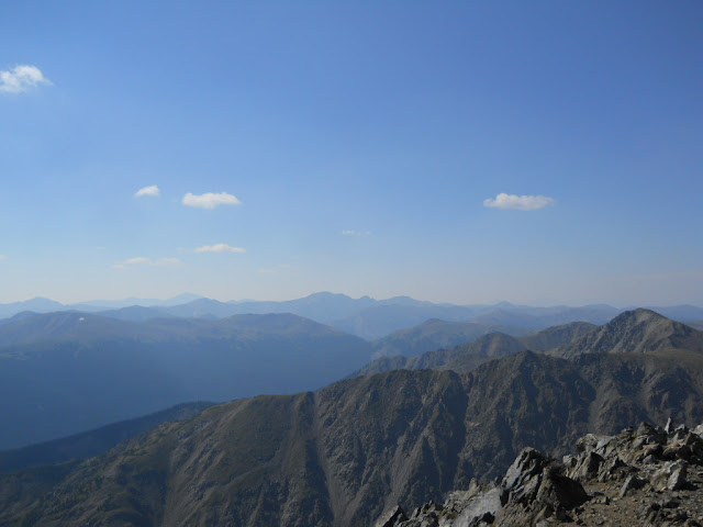


Ran the loop around the Keyser Creek basin today, with summits of Byers Peak (12,804') and Bills Peak (12,703'). This is another excellent loop run traversing a high alpine basin in the Vasquez Wilderness. I started at the Deadhorse trailhead, running up the secret trail until hitting the road to the Byers Peak trailhead. From there, I ran up the Byers Peak trail to the summit of Byers. From here, you descend off the south side of Byers, following the ridge. There is no trail from Byers to Bills, but it is fairly obvious and the ridge holds a fun section of 2/3 class scrambling. Once you are on Bills, you are at the southern end of the Keyser Creek basin, and can look across towards Bottle and your way back home. From Bills Peak, you run down west and then north along the long Bills Peak ridge mostly off trail, although there are faint markings for the St. Louis trail. Take this all the way back to treeline, and when you can see Lake Evylen on your left (west), go another couple hundred yards on the ridge and then make a sharp turn back east and south and drop into the Keyser basin. There are some cairns here, but the trail pretty much disappears in the basin, as you descend and then follow along Keyser Creek. Every once and awhile you will see a cairn, but I spent some time trying to figure out just which way to go. Eventually the trail re-appears and you can follow it to the junction for Bottle Pass. Run back up and over Bottle Pass and then back down the other side to the regular Byers Peak trail. From here, just head on back down and retrace your steps.
Byers Peak sees some traffic (I ran into one party on it today, Sunday), but Bills rarely sees anyone on the summit, and from Byers to Bills and into the basin and then back to Bottle Pass you will not see anyone. It is evident just how empty this area is (it is an official wilderness area) by the fact that the trail really does not exist along this entire way - you are mostly running on alpine tundra and then scree and mossy grass down in the basin (so it can be slow going at times). The full loop is 19.1 miles with ~6,100' of gain and ~6,100' of loss. Today I ran the loop in 4:44 with time for pictures and food on the summits. The loop can be done faster, but since this was my first time, I spent a little time trying to find my way in the Keyser basin and enjoying the views.


Looking at Bills from Byers summit

South off of Byers summit

Looking back at Byers from Bills summit

Looking back at Bills after the long ridge around the basin

The sign in the bottom of the basin showing you are on the right path
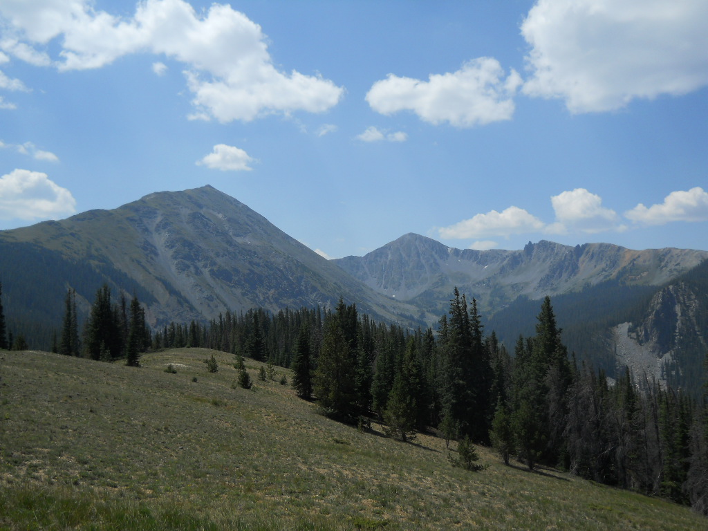
From the fake Bottle Pass looking at the Keyser Creek basin. The run follows the skyline from left to right and beyond
Subscribe to:
Posts (Atom)